多伦多买房租房要避开的问题社区(NIA)
一、什么是“问题社区”
“问题社区”顾名思义就是问题比较多的社区,包括贫困率高、失业率高、犯罪率高等,多伦多市政会定期出报告,比较委婉地称呼这些问题社区为Neighbourhood Improvement Areas(NIAs)。因为这种社区存在问题很多,物业升值潜力差,严重的会危及生命安全,因此,多伦多最新最全的楼花搜索引擎Comecondo.com提醒您,当您在多伦多买房或者租房时,一定事先了解社区的情况,严格避开这些问题社区。
二、2022年多伦多“问题社区”(按社区名称排列)
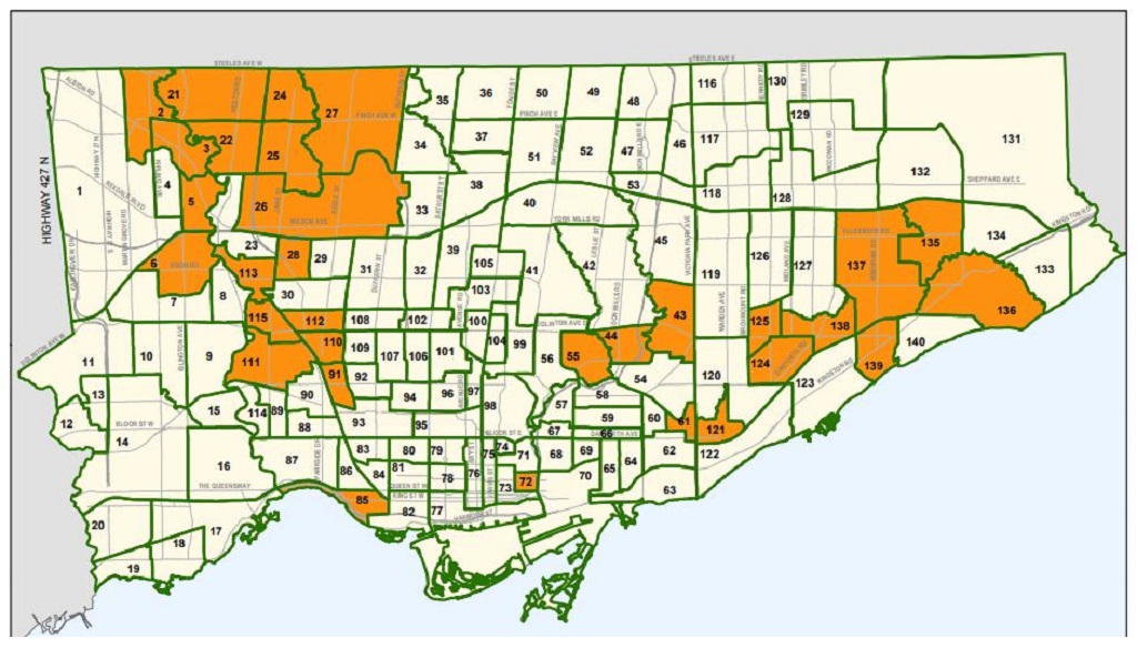
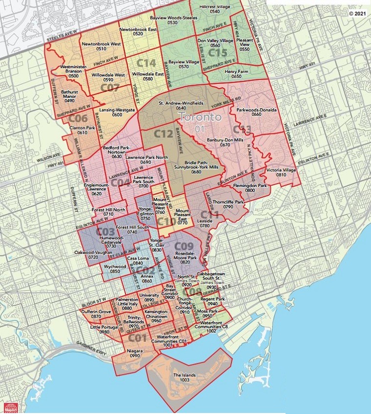
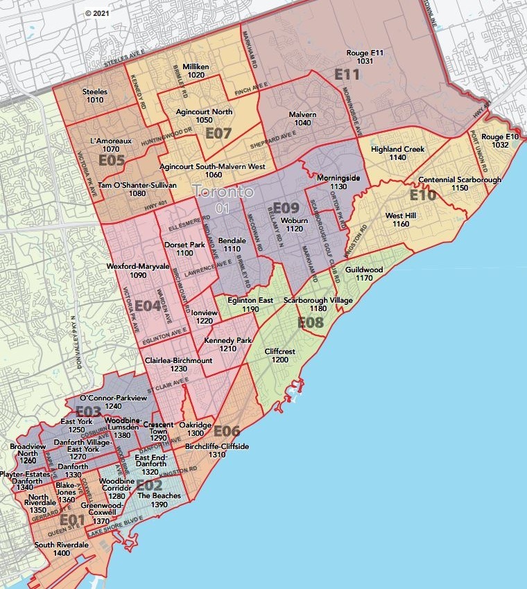
首先需要说明的是,我们这里所指的“多伦多”是包括多伦多主区、世嘉堡、北约克以及怡陶碧谷这几个行政区的,从上方配图可以看出问题社区的大致分布情况。2020年多伦多市政报告统计的“问题社区”具体包括:
| 社区名称 | 社区编号 | 社区描述 | |
| York University Heights | 27 | The neighbourhood, York University Heights is located in the Northern part of North York. The neighbourhood boundary for York University Heights starts where the Black Creek intersects with Steeles Avenue West. The boundary then continues East on Steeles Avenue West to Dufferin Street. At Dufferin Street, the boundary continues South to Sheppard Avenue West. At Sheppard Avenue West, the boundary continues West to the Black Creek. Once at the Black Creek, the boundary continues North back to Steeles Avenue West. | |
| Beechborough-Greenbrook | 112 | The neighbourhood, Beechborough-Greenbrook is located in the central part of Toronto. The neighbourhood boundary for Beechborough-Greenbrook starts where a property line located in between Lawrence Avenue West and Eglinton Avenue West, intersects with the Canadian National Railway/Canadian Pacific Railway. The boundary continues East along the property line to another set of Canadian National Railway tracks. At the Canadian National Railway, the boundary continues South to Eglinton Avenue West. At Eglinton Avenue West, the boundary continues West to the Canadian National Railway/Canadian Pacific Railway. At the Canadian National Railway/Canadian Pacific Railway, the boundary continues North back to the property line. | |
| Black Creek | 24 | The neighbourhood, Black Creek is located in the Northern part of North York. The neighbourhood boundary for Black Creek starts at the Steeles Avenue West and Highway 400 intersection. The boundary continues East on Steeles Avenue West to the Black Creek. At the Black Creek, the boundary continues South to Finch Avenue West. At Finch Avenue West, the boundary continues West to Highway 400. At Highway 400, the boundary continues North, back to Steeles Avenue West. | |
| Downsview | 155 | The neighbourhood, Downsview is located in the Western part of North York. The neighbourhood boundary for Downsview starts where the Black Creek intersects with Sheppard Avenue West. The boundary continues east along Sheppard Avenue West to Banting Avenue. At Banting Avenue, the boundary continues south to Reiner Road. At Reiner Road, the boundary continues east to Wilson Heights Boulevard. At the Wilson Heights Boulevard and Reiner Road intersection, the boundary then continues South on Wilson Heights Boulevard to a planning boundary line located within Downsview Park. The boundary continues southwest along the planning boundary line in Downsview park to Wilson Avenue. At Wilson Avenue, the boundary then continues west to Dufferin Street. At Dufferin Street, the boundary continues south to Highway 401. The boundary then continues west along Highway 401 to Keele Street. At Keele Street the boundary turns north to Wilson Avenue and goes west to Agate Road. At Agate Road, the boundary goes north, then turns west on Victory Drive, then north on Ianhall Road, then west of Gade Drive to Roding Street. The boundary continues north on Roding Street to Langholm Drive and turns west. At the end of Langhold Drive the boundary line connects to Black Creek. At the Black Creek, the boundary continues north back to Sheppard Avenue West. | |
| East.Flemingdon Park | 44 | The neighbourhood, Flemingdon Park is located in the Eastern part of North York. The neighbourhood boundary for Flemingdon Park starts where the Don River West Branch intersects with Eglinton Avenue East. At Eglinton Avenue East, the boundary continues East to the Don River East Branch. At the Don River East Branch, the boundary continues South along the river to a property line located parallel to the Canadian National Railway. The boundary follows the property line South-West along the Canadian National Railway, to the Don River West Branch. At the Don River West Branch, the boundary continues North back to Eglinton Avenue. | |
| Eglinton East | 138 | The neighbourhood, Eglinton East is located in central Scarborough. The neighbourhood boundary for Eglinton East starts where the Canadian National Railway tracks running between Kennedy Road and Midland Avenue intersect with Tara Avenue. The boundary travels east along Tara Avenue to Midland Avenue. At Midland Avenue, the boundary then continues south for a small distance to Stansbury Crescent. The boundary follows Stansbury Crescent to the east and then, where Stansbury meets Citadel Drive in a T-junction, east along Citadel Drive. At the intersection of Citadel Drive and Brimley Road, the boundary continues north along Brimley Road until it meets West Highland Creek. At West Highland Creek, the boundary then follows the creek east to Bellamy Road North. At Bellamy Road North, the boundary turns south to the Canadian National Railway tracks just north of Eglinton Avenue East. The boundary then follows the tracks west to Brimley Road. At Brimley Road, the boundary then continues north until it meets Eglinton Avenue East. The boundary then continues west along Eglinton Avenue East to the Canadian National Railway tracks. The boundary then follows the Canadian National Railway tracks north back to Tara Avenue. | |
| Elms-Old Rexdale | 5 | The neighbourhood, Elms-Old Rexdale is located in the Eastern part of Etobicoke. The neighbourhood boundary for Elms-Old Rexdale starts at the intersection of Islington Avenue and the Humber River West Branch. The boundary continues East along the Humber River West Branch to where it intersects with the Humber River. The boundary then continues South along the Humber River to Highway 401. At Highway 401, the boundary then continues West to Islington Avenue. At Islington Avenue, the boundary then continues North back to the Humber River West Branch. | |
| Golfdale-Cedarbrae-Woburn | 141 | The neighbourhood, Golfdale-Cedarbrae-Woburn is located in the central to southern part of Scarborough. The neighbourhood boundary for Golfdale-Cedarbrae-Woburn starts at the intersection of Ellesmere Road and Scarborough Golf Club Road, the boundary turns south along Scarborough Golf Club Road. When Scarborough Golf Club Road meets Brimorton Drive, the boundary then travels east along Brimorton Drive. At the intersection of Brimorton Drive and Orton Park Road, the boundary turns south along Orton Park Road to Lawrence Avenue East. At Lawrence Avenue East, the boundary continues east until West Highland Creek. At West Highland Creek, the boundary follows the creek to the south until it turns south following a property line that extends south toward, and then west of Livingston Road North. The boundary follows the property line south, then west, then south until it intersects with the Canadian National Railway tracks. At the Canadian National Railway, the boundary continues west along the railway to Bellamy Road North. The boundary turns north on Bellamy Road North to West Highland Creek. The boundary then follows West Highland Creek to the west until Lawrence Avenue East. The boundary then follows Lawrence Avenue East to the east to Markham Road. The boundary follows Markham Road north to Ellesmere Road then goes east on Ellesmere Road back to the intersection of Ellesmere Road and Scarborough Golf Club Road. | |
| Glenfield-Jane Heights | 25 | The neighbourhood, Glenfield-Jane Heights is located in the North-West part of North York. The neighbourhood boundary for Glenfield-Jane Heights starts at the intersection of Highway 400 and Finch Avenue West. The boundary continues East along Finch Avenue West to the Black Creek. At the Black Creek, the boundary follows the river South-East to Jane Street. At Jane Street, the boundary continues North to Sheppard Avenue West. At Sheppard Avenue West, the boundary continue West to Highway 400. At Highway 400, the boundary continues North back to Finch Avenue West. | |
Humbermede | 22 | The neighbourhood, Humbermede is located in the North-West part of North York. The neighbourhood boundary for Humbermede starts where the Humber River East Branch intersects with Finch Avenue West. The boundary continues East along Finch Avenue West to Highway 400. At Highway 400, the boundary continues South to Sheppard Avenue West. At Sheppard Avenue West, the boundary continues West to a property line that connects Sheppard Avenue West to the Humber River East Branch, cutting through Humber Sheppard Park. The boundary continues West along the property line to the Humber River East Branch. The boundary then continues North along the Humber River East Branch, back to Finch Avenue West. | |
| Humber Summit | 21 | The neighbourhood, Humber Summit is located in the North-West part of North York. The neighbourhood boundary for Humber Summit starts where a property line connecting the Humber River East Branch to Steeles Avenue West intersects with Steeles Avenue West. The boundary continues East on Steeles Avenue West to Highway 400. At Highway 400, the boundary continues South to Finch Avenue West. At Finch Avenue West, the boundary continues West to the Humber River East Branch. At the Humber River East Branch, the boundary continues North along the river, to the property line connecting the Humber River East Branch to Steeles Avenue West. The boundary then continues East along the property line, back to Steeles Avenue West. | |
| Ionview | 125 | The neighbourhood, Ionview is located in central Scarborough. The neighbourhood boundary for Ionview starts at Birchmount Road and the hydro transmission corridor located south of Flora Drive. The boundary follows the hydro corridor to the Canadian National Railway tracks between Kennedy Road and Midland Avenue. The boundary follows the Canadian National Railway south until it meets Eglinton Avenue East. At Eglinton Avenue East, the boundary continues west towards Kennedy Road, turning south along Kennedy Road until the Canadian National Railway tracks just south of Eglinton Avenue East. The boundary follows the Canadian National Railway southwest until it meets Birchmount Road. From here, the boundary then continues north on Birchmount Road, connecting back to the hydro corridor. | |
| Keelesdale-Eglinton West | 110 | The neighbourhood, Keelesdale-Eglinton West is located in the central part of Toronto. The neighbourhood boundary for Keelesdale-Eglinton West starts where the Canadian National Railway/Canadian Pacific Railway tracks intersect with Eglinton Avenue West. The boundary continues East along Eglinton Avenue West to the Canadian National Railway. At the Canadian National Railway, the boundary continues South to a property line located between Rowntree Avenue and Lavender Road. The boundary then continues West along the property line to the Canadian National Railway/Canadian Pacific Railway. At the Canadian National Railway/Canadian Pacific Railway, the boundary continues North back to Eglinton Avenue West. | |
| Kennedy Park | 124 | The neighbourhood, Kennedy Park is located in central Scarborough. The neighbourhood boundary for Kennedy Park starts at the intersection of Eglinton Avenue East and Kennedy Road. The boundary continues east along Eglinton Avenue East until it meets Brimley Road. The boundary continues south along Brimley Road to the Canadian National Railway tracks south of Danforth Road. The boundary follows the railway tracks to the southwest until meets St. Clair Avenue East. The boundary then heads west along St. Clair Avenue East to Birchmount Road. The boundary turns north, running along Birchmount Road until it intersects with another set of Canadian National Railway tracks north of Foxridge Drive. The boundary continues northeast along the tracks to Kennedy Road, where it turns north, continuing back up to Eglinton Avenue East. | |
| Kingsview Village-The Westway | 6 | The neighbourhood, Kingsview Village-The Westway is located in the central part of Etobicoke. The neighbourhood boundary for Kingsview Village-The Westway starts at the intersection of Dixon Road and Highway 401. The boundary continues North-East along Highway 401 to the Humber River. At the Humber River, the boundary continues South to St. Philips Road. The boundary then continues South on St. Philips Road to Royal York Road. At Royal York Road, the boundary then continues South to The Westway. At The Westway, the boundary continues South-West to Kipling Avenue. At Kipling Avenue, the boundary continues North to Dixon Road. At the Kipling Avenue and Dixon Road intersection, the boundary continues West on Dixon Road back to Highway 401. | |
| Mount Dennis | 115 | The neighbourhood, Mount Dennis is located in the central part of Toronto. The neighbourhood boundary for Mount Dennis starts where the Humber River intersects with a property line that connects to Clouston Avenue. The boundary follows the property line East, which eventually turns into Clouston Avenue, to Centre Road. At Centre Road, the boundary continues South to Edmund Avenue. At Edmund Avenue, the boundary continues East to Weston Road. At the intersection of Weston Road and Edmund Avenue, the boundary continues North on Weston Road to Clouston Avenue. At Clouston Avenue, the boundary continues East to a property line parallel to the shared Canadian National Railway/Canadian Pacific Railway tracks. The boundary continues South along the property line to another property line that connects the property line parallel to the Canadian National Railway/Canadian Pacific Railway, to the actually Canadian National Railway/Canadian Pacific Railway tracks. The boundary then follows the Canadian National Railway/Canadian Pacific Railway tracks, South, to Lambton Avenue. At Lambton Avenue, the boundary continues West to Jane Street. At the Jane Street and Lambton Avenue intersection, the boundary then continues North on Jane Street to Eglinton Avenue West. At Eglinton Avenue West, the boundary then continues West to the Humber River. The boundary then continues North along the Humber River, back to the property line that connects to Clouston Avenue. | |
| Mount Olive-Silverstone-Jamestown | 2 | The neighbourhood, Mount Olive-Silverstone-Jamestown located in the North-East part of Etobicoke. The neighbourhood boundary for Mount Olive-Silverstone-Jamestown neighbourhood starts at the intersection of Martin Grove Road and Steeles Avenue West. The boundary continues East along Steeles Avenue West to a property line that runs through Thackeray Park, connecting Steeles Avenue West to the Humber River East Branch. The boundary then continues East along the property line to the Humber River East Branch. At the Humber River East Branch, the boundary then continues South to Finch Avenue West. The boundary then continues West along Finch Avenue West to a property line located slightly East of Farr Avenue. The boundary then continues North along the property line, to another property line located North of Farr Avenue. The boundary then continues West along the property line to Kipling Avenue. At Kipling Avenue, the boundary continues South to the Humber River West Branch. At the Humber River West Branch, the boundary then continues South-West to Martin Grove Road. At Martin Grove Road, the boundary then continues North back to Steeles Avenue West. | |
| Morningside | 135 | The neighbourhood, Morningside is located in western-central Scarborough. The neighbourhood boundary for Morningside starts where East Highland Creek passes under Highway 401. The boundary follows Highway 401 to the east to Morningside Avenue. The boundary then continues south along Morningside Avenue to Highland Creek. The boundary then follows the creek southwest until it meets Lawrence Avenue East. At Lawrence Avenue East, the boundary turns West to Orton Park Road. At the intersection of Orton Park Road and Lawrence Avenue East, the boundary turns north, following Orton Park Road to Brimorton Drive. At Brimorton Drive, the boundary continues west to Scarborough Golf Club Road. At Scarborough Golf Club Road, the boundary turns north to Ellesmere Road, where it continues east on Ellesmere Road. When Ellesmere Road meets East Highland Creek, the boundary then follows East Highland Creek north back to Highway 401. | |
| Oakdale-Beverley Heights | 154 | The neighbourhood, Oakdale-Beverley Heights is located in the Western part of North York. The neighbourhood boundary for Oakdale-Beverley Heights starts where the Canadian Pacific Railway intersects with Sheppard Avenue West. The boundary continues east on Sheppard Avenue East to Jane Street. At Jane Street, the boundary continues south until Jane Street intersects with Black Creek. The boundary then follows Black Creek and the boundary line connects to the end of Langholm Drive. The boundary briefly goes along Langholm Drive and turns south on Roding Street to Gade Drive. The boundary goes east on Gade Drive to Ianhall Road, then turns east on Victory Drive to Agate Road then turns south to Wilson Avenue. The boundary goes east along Wilson Avenue and turns south on Keele Street to Highway 401. The boundary then continues west along Highway 401 to the Canadian Pacific Railway. At the Canadian Pacific Railway, the boundary continues North back to Sheppard Avenue West. | |
Oakridge | 121 | The neighbourhood, Oakridge is located in the western part of Scarborough. The neighbourhood boundary for Oakridge starts at the intersection of Victoria Park Avenue and Massey Creek, the boundary follows Massey Creek east and then northeast to St. Clair Avenue East. At St. Clair Avenue East, the boundary turns briefly eastward until it meets Warden Avenue. At the Warden Avenue and St. Clair West intersection, the boundary continues south along Warden Avenue to a planning boundary line that runs eastward about 100m north of Mack Avenue. The boundary then follows the planning boundary line past Danforth Road to another property line which runs perpendicular to the south. The boundary then follows the perpendicular planning boundary line southwest across Mack Avenue, running alongside Milne Avenue and then curving to eventually meet the Canadian National Railway tracks to the south just north of where the tracks cross Danforth Avenue. The boundary then follows the path of the Canadian National Railway tracks, continuing west to Victoria Park Avenue. At Victoria Park Avenue, the boundary turns north, continuing until it meets Massey Creek. | |
| Regent Park | 72 | The neighbourhood, Regent Park is located in the central part of Toronto. The neighbourhood boundary for Regent Park starts at the intersection of Gerrard Street East and Parliament Street. The boundary continues East on Gerrard Street East to the Don River. At the Don River, the boundary continues South to Queen Street East. The boundary then continues West along Queen Street East to Parliament Street. At Parliament Street, the boundary continues North back to Gerrard Street East. | |
| Rockcliffe-Smythe | 111 | The neighbourhood, Rockcliffe-Smythe is located in the central part of Toronto. The neighbourhood boundary for Rockcliffe-Smythe starts where Eglinton Avenue West and the Humber River intersect. The boundary continues East along Eglinton Avenue West to Jane Street. At Jane Street, the boundary continues South to Lambton Avenue. At the intersection of Jane and Lambton Avenue, the boundary continues East on Lambton Avenue to the Canadian National Railway/Canadian Pacific Railway tracks. At the Canadian National Railway/Canadian Pacific Railway tracks, the boundary then follows the railway tracks South, to a property line located in between Cayuga Avenue and Northland Avenue. The boundary follows the property line, West, towards another property line located between Lapp Street and Maybank Avenue. The boundary the follows the property line between Lapp Street and Maybank Avenue, South, to another property line that is located in the Ontario Hydro Lands. The boundary continues West along the Ontario Hydro Lands property line to a property line located East of Blakley Avenue. The boundary continues West along this property line to Runnymede Road. At Runnymede Road, the boundary continues South to the Canadian National Railway tracks. The boundary then continues West along the Canadian National Railway until it intersects with the Humber River. At the Humber River, the boundary then continues North, back to Eglinton Avenue West. | |
| Rustic | 28 | The neighbourhood, Rustic is located in the central part of North York. The neighbourhood boundary for Rustic starts at the intersection of Highway 401 and Jane Street. The boundary continues East along Highway 401 to Culford Road. At Culford Road, the boundary continues South to Lawrence Avenue West. The boundary then continues West on Lawrence Avenue West to Jane Street. At Jane Street, the boundary then continues North back to Highway 401. | |
| South Parkdale | 85 | The neighbourhood, South Parkdale is located in the Southern part of Toronto. The neighbourhood boundary for South Parkdale starts where the Humber River intersects with the Canadian National Railway. The boundary follows the Canadian National Railway East, to Martin Goodman Trail. At Martin Goodman Trail the boundary continues North to Queen Street West. At Queen Street West, the boundary continues East to the Canadian National Railway/Canadian Pacific Railway tracks. At the Canadian National Railway/Canadian Pacific Railway tracks, the boundary continues South-East to a property line that connects the railway tracks to Atlantic Avenue. The boundary then continues South along the property line to Atlantic Avenue. At Atlantic Avenue the boundary continues South to the Canadian National Railway. At the Canadian National Railway, the boundary continues West to a property line, which connects the Canadian National Railway to Lake Ontario. The boundary follows the property line South, across the Gardiner Expressway, through Marilyn Bell Park, to Lake Ontario. Once the boundary meets Lake Ontario, it continues West along the lake to the Humber River. At the Humber River, the boundary continues North, back to the Canadian National Railway. | |
| Scarborough Village | 139 | The neighbourhood, Scarborough Village is located in the southern part of Scarborough. The neighbourhood boundary for Scarborough Village starts where the Canadian National Railway meets a property line that runs perpendicular to Eglinton Avenue East between Bellamy Road North and Bellamy Road South. The boundary follows the Canadian National Railway northeast to Scarborough Golf Club Road. At Scarborough Golf Club Road, the boundary heads south to Hill Crescent. The boundary follows Hill Crescent southwest until it intersects with Bethune Boulevard. The boundary then follows Bethune Boulevard south to Sylvan Avenue. At Sylvan Avenue, the boundary travels to the northeast to Rogate Place. The boundary then follows Rogate Place south to the end of the road and continuing south in a straight line following a property line running through South Marine Drive Park. When the property line meets Lake Ontario, the boundary then follows the shore of Lake Ontario west to Bellamy Ravine Creek. The boundary then continues north along Bellamy Ravine Creek to Kingston Road. At Kingston Road, the boundary turns east to Bellamy Road South. At the intersection of Kingston Road and Bellamy Road South, the boundary continues north back to the Canadian National Railway. | |
| Taylor-Massey | 61 | The neighbourhood, Taylor Massey is located in East York. The neighbourhood boundary for Taylor Massey starts at the intersection of Dawes Road and Grower Street. The boundary continues East along Grower Street to Victoria Park Avenue. At Victoria Park Avenue, the boundary continues South to a property line located South of Danforth Avenue and North of the Canadian National Railway. The boundary continues West along the property line to another property line connecting from just South of the Canadian National Railway to Dentonia Park Avenue. The boundary continues North along the property line to Dentonia Park Avenue. The boundary continues West on Dentonia Park Avenue to Avonlea Boulevard. At Avonlea Boulevard, the boundary continues South to a property line that connects Avonlea Boulevard to Main Street. The boundary then continues West along the property line to Main Street. At Main Street, the boundary continues North to a property line which extends out of Main Street and into Taylor Creek Park. The boundary continues North along the property line to another property line located parallel to the hydro line. The boundary continues South-East along the property line until it intersects with Dawes Road. At Dawes Road, the boundary continues North back to Gower Street. | |
| Thistletown-Beaumond Heights | 3 | The neighbourhood Thistletown-Beaumond Heights is located in the Eastern part of Etobicoke. The neighbourhood boundary for Thistletown-Beaumond Heights starts where Kipling Avenue intersects with a property line located slightly North of Farr Avenue. The boundary then continues East along the property line to another property line located slightly East of Farr Avenue. The boundary then continues South along the property line located East of Farr Avenue to Finch Avenue West. At Finch Avenue West, the boundary continues East to the Humber River East Branch. The boundary then continues South along the Humber River East Branch to a property line located through Albion Gardens Park. The boundary continues South-West and then North-East, connecting back to the Humber River East Branch. The boundary then continues South-West along the Humber River East Branch to the Humber River West Branch. Once the two rivers intersect, the boundary continues North-West along the Humber River West Branch to Kipling Avenue. At Kipling Avenue, the boundary then continues North back to the property line North of Farr Avenue. | |
| Thorncliffe Park | 55 | The neighbourhood, Thorncliffe Park is located in East York. The neighbourhood boundary for Thorncliffe Park starts at the intersection of Laird Drive and Eglinton Avenue East. The boundary continues East on Eglinton Avenue East to the Don River West Branch. At the Don River West Branch, the boundary continues South along the river to the Don River. When the Don River West Branch and the Don River intersect, the boundary continues West along the Don River to Leaside Bridge. At Leaside Bridge, the boundary continues North to Millwood Road. The boundary continues North-West along Millwood Road, until Millwood Road turns into Laird Drive. The boundary then continues North on Laird Drive, back to Eglinton Avenue. | |
| Victoria Village | 43 | The neighbourhood, Victoria Village is located in the Eastern Part of North York. The neighbourhood boundary for Victoria Village starts where the Don River East Branch intersects with Lawrence Avenue East. At Lawrence Avenue East, the boundary continues East to Victoria Park Avenue. At Victoria Park Avenue, the boundary continues South to a property line located North of Holland Avenue, connecting Victoria Park Avenue to O’Connor Drive. The boundary continues West along the property line to O’Connor Drive. At O’Connor Drive, the boundary continues North to Northline Road. At Northline Road, the boundary continues West to a property line located East of Bermondsey Road, and connects Northline Road to Sunrise Avenue. The boundary continues North along the property line to Sunrise Avenue. At Sunrise Avenue, the boundary continues West to a property line that extends through the Northline Parks Yard Building Grounds, and connects Sunrise Avenue to the Don River East Branch. The boundary then continues along the property line to the Don River East Branch. At the Don River East Branch, the boundary continues North along the river to back to Lawrence Avenue East. | |
| West Hill | 136 | The neighbourhood, West Hill is located in western Scarborough. The neighbourhood boundary for West Hill starts where a property line runs north from the Canadian National Railway tracks just to the west of Livingston Road North. The property line connects with West Highland Creek and the boundary continues northeast along the West Highland Creek to the Highland Creek. The boundary then arcs to the southwest, following Highland Creek to where it meets Lake Ontario at East Point Park. The boundary then continues west along the lake shore to West Hill Creek. The boundary follows West Hill Creek north to the Canadian National Railway. At the Canadian National Railway, the boundary continues west to the property line near Livingston Road North. | |
| Weston | 113 | The neighbourhood, Weston is located in the central part of Toronto. The neighbourhood boundary for Weston starts where the Humber River intersects with a property line located North of Oak Street. The boundary follows the property line East to the Canadian Pacific Railway. The boundary then follows the Canadian Pacific Railway South-East to a property line that connects the Canadian Pacific Railway to Rosemount Avenue. The boundary then continues East along the property line to Rosemount Avenue. Once at Rosemount Avenue, the boundary continues North to Queenslea Avenue. At Queenslea Avenue, the boundary continues East to Grattan Street, where the boundary continues South to a property line. At the property line perpendicular to Grattan Street and just South of Queenslea Avenue, the boundary continues East on the property line to Walwyn Avenue. The boundary then continues South on Walwyn Avenue to a property line just South of Lamont Avenue. The boundary then continues East along the property line, which eventually turns into Woodward Avenue, to Jane Street. At the intersection of Jane Street and Woodward Avenue, the boundary continues South on Jane Street to a property line located South of Romanway Crescent, and cuts through James Trimbee Park. The boundary then follows the property line West to another property line located parallel to the shared Canadian National Railway/Canadian Pacific Railway tracks. The boundary then continues South-East along the property line to Denison Road East. At Denison Road East, the boundary continues East to Jane Street. At the Jane Street and Denison Road East intersection, the boundary continues South on Jane Street to a property line located South on Denison Road East. The boundary then follows the property line West and then South, to a property line that is connected to Clouston Avenue. The boundary then continues West along the property line, eventually connecting to Clouston Avenue, to Weston Road. At the Weston Road and Clouston Avenue intersection, the boundary then continues South on Weston Road to Edmund Avenue. At Edmund Avenue, the boundary continues West to Centre Road. At Centre Road, the boundary continues North back to Clouston Avenue. The boundary then continues West on Clouston Avenue to a property line that connects Clouston Avenue to the Humber River. The boundary then continues West along the property line to the Humber River. The boundary then follows the Humber River North-West, back to the property line located North of Oak Street. | |
| Weston-Pelham Park | 91 | The neighbourhood, Weston-Pelham Park is located in the central part of Toronto. The neighbourhood boundary for Weston-Pelham Park starts where a property line located slightly South of Lavender Road, intersects with the Canadian National Railway/Canadian Pacific Railway tracks. The boundary continues East along this property line to the Canadian National Railway. The boundary then follows the railway South to the Canadian Pacific Railway. Where the Canadian National Railway and Canadian Pacific Railway meet, the boundary continues West along the Canadian Pacific Railway, back to the Canadian National Railway/Canadian Pacific Railway tracks. | |
| Woburn North | 142 | The neighbourhood, Woburn North is located central Scarborough. The neighbourhood boundary for Woburn North starts where Highway 401 and McCowan Road intersect. The boundary follows Highway 401 to the east to East Highland Creek. The boundary then follows East Highland Creek to the south to Ellesmere Road. When the East Highland Creek meets Ellesmere Road, the boundary then turns west along Ellesmere Road. At the intersection of Ellesmere Road and Markham Road the boundary turns south along Markham Rd. At the intersection of Markham Road and Lawrence Avenue East the boundary turns west along Lawrence Avenue East. At the intersection of Lawrence Avenue East and McCowan Road the boundary turns north along McCowan Road back to Highway 401. |

您可能感兴趣的相关话题
- 加拿大购房按揭贷款负担能力计算
- 在安省如何办理购房贷款预先批准?
- 必须购买CMHC(加拿大按揭与房屋公司)房屋贷款保险吗?
- 加拿大购房支付首付款要注意哪些问题?
- 购房贷款利率应该选固定还是浮动的?
- 在加拿大购房应该如何选择购房贷款的期限?
- 针对有关购房贷款的规定及条款的最详细解读
- 在加拿大办理购房贷款应该如何选择贷款机构?
- 在加拿大想要成功申请贷款你需要满足哪些条件?
- 加拿大不同贷款机构的政策和利率
- 在安省买房会涉及的律师费
- 加拿大卖房全流程详解
- 卖房前如何升级厨房卫生间?
- 楼花转让卖家需要做哪些准备工作?
- 过桥贷款(Bridge Financing)
- 究竟应该买房还是租房?
- 和别人一起买房需要注意哪些问题?
- 买房涉及的律师费
- 在安省买房有哪些成本
- 加拿大首次购房者计划(HBP)
- 首次购房者激励计划(FTHBI)
- 首次购房者税收抵免(Tax Credit)
- 首次购房者安省土地转让税退税(Land Transfer Tax Rebate)
- 楼花投资的那些事(上)
- 楼花购买及交接流程
- 安省最通用的房屋购买协议重要条款解读
- 买家如何从容应对抢offer/bidding war的状态?
- 买家验房有哪些注意事项?
- 下offer时交的定金(deposit)有什么具体规定吗?
- 买卖双方都应该遵守的下offer的流程介绍
- 买卖房子过程中提出的条件(Condition)包括哪些?
楼花所在城市
多伦多市中心|Toronto Downtown
北约克|North York
世嘉堡|Scarborough
怡陶碧谷| Etobicoke
密西沙加| Mississauga
奥克维尔| Oakville
万锦| Markham
旺市| Vaughan
列治文山| Richmond Hill
Aurora/Barrie/Newmarket/East Gwillimbury/Uxbridge
汉密尔顿| Hamilton
基奇纳、滑铁卢、剑桥| Kitchener, etc
皮克林Pickering/Ajax/Whitby/Oshawa
伯林顿| Burlington
米尔顿| Milton
蒙特利尔 | Montreal
卡尔加里| Calgary
楼花发售阶段
即将发售| Coming Soon
内部发售| VVIP Sales
尾盘在售| Final Sales
发售完毕| Sold Out
楼花转让| Assignments
楼花项目开发商
Aspen Ridget Homes
Camrost Felcorp
CentreCourt Developments
Concord Adex
Elad Canada
Graywood Developments
Great Gulf
Lanterra Developments
Liberty Developments
Lifetime Developments
Mattamy Homes
Menkes Developments
Minto Group
Pinnacle International
Tridel
Tribute Communities
Times Group
The Conservatory Group
The Daniels Corporation
The Remington Group
Sorbara
Primont Homes
Westdale Properties
Zancor Homes
更多开发商…
Riverview Condos
万锦市Unionville社区
Highway 7 & Birchmount Rd
有少量2bed+den及以上单位在售,$1,880,800
2022年5月开始入住 ...
NUVO Condos
奥克维尔West Oak Trails社区
2343 Khalsa Gate, Oakville
二手公寓在租/在售,售价$50余万起
2024年冬开始入住 ...
Residences at Parkside Village
密西沙加市中心
4065 Brickstone Mews
二手公寓在售,起价$50余万
2013年开始入住 ...
Arc Condos
密西沙加Central Erin Mills社区
2550 Eglinton Ave W
二手公寓在租/在售,起价$40余万
2019年春开始入住 ...
Distrikt Trailside Condos 2
奥克维尔Uptown Core社区
395 Dundas St W, Oakville
二手公寓在租/在售,售价$499,990起
2025年1月开始入住 ...
The Saw Whet Condos
奥克维尔Glen Abbey社区
Bronte Rd & Upper Middle Rd
楼花转让,起价$579,900
2025年2月开始入住 ...
Distrikt Trailside Condos
奥克维尔Uptown Core社区
405 Dundas St W, Oakville
二手公寓在租/在售,售价$499,990起
2024年夏开始入住 ...
NUVO Condos 2
奥克维尔West Oak Trails社区
2333 Khalsa Gate, Oakville
二手公寓在租/在售,售价$50余万起
2024年秋开始入住 ...
Prime Condos
319 Jarvis St, Toronto
Jarvis St & Gerrard St E
二手公寓在租/在售,售价$50余万起
2024年2月开始入住 ...
The Tailor Condos
怡陶碧谷The Queensway社区
Kipling Ave & The Queensway
二手公寓在售/在租,售价$40余万起
2023年开始入住 ...
DunWest Condos
509 Dundas St West
Neyagawa Blvd & Dundas St W
二手公寓在租/在售,售价$50余万起
2023年6月开始入住 ...
Social Condos
多伦多Garden District社区
Church St & Dundas St E
二手公寓在租/在售,售价$40余万起
2023年11月开始入住 ...
Valhalla Town Square Condos
East Mall & Bloor St W
10, 26 & 30 Gibbs Rd
二手公寓在租/在售,售价$50余万起
2022年10月开始入住 ...
Beverley at the Thornhill
2 Beverley Glen Blvd & 7950 Bathurst St, Thornhill
Bathurst St & Centre St
二手公寓在租/在售,售价$50余万起
2024年春开始入住 ...
8888 Yonge Street Condos
8888 Yonge St
Westwood Ln & Yonge Street
二手公寓在租/在售,售价$50余万起
2024年6月开始入住 ...
Auberge On The Park Condos
30 Inn On The Park Dr
Leslie St & Eglinton Ave E
二手公寓在租/在售,售价$50余万起
2024年春开始入住 ...
Auberge On The Park Condos 2
20 Inn On The Park Dr
Leslie St & Eglinton Ave E
二手公寓在租/在售,售价$50余万起
2024年3月开始入住 ...
36 Zorra Condos
36 Zorra St, Etobicoke
The Queensway & Kipling Ave.
二手公寓在租/在售,售价$50余万起
2024年4月开始入住 ...
199 Church Condos
82 Dalhousie St, Toronto
Church St & Dundas St E
二手公寓在租/在售,售价$50余万起
2024年3月开始入住 ...
Sugar Wharf Condos 1& 2
Queens Quay E & Freeland St
55 Cooper St & 138 Downes St, Toronto
二手公寓在租/在售,售价$50余万起
2024年4月开始入住 ...
M2M Condos
Cummer Ave & Yonge St
5915 Yonge St, North York
二手公寓在售/在租,售价$50余万起
一期2024年,二期2027年开始入住 ...
Rise at Stride Condos
Lakeshore Rd E & Enola Ave
1063 Douglas Mccurdy Common
二手公寓在售/在租,售价$50余万起
2023年6月开始入住 ...
Rodeo Drive Condos 1
Leslie St & Eglinton Ave E
20 O'neill Rd
二手公寓在租/在售,售价$50余万
2022年12月开始入住 ...
KSquare Condos
Kennedy Rd & Sheppard Ave E
2035 Kennedy Rd
二手公寓在租/在售,售价$50余万起
2023年秋开始入住 ...
50 Wellesley Condos
Yonge St & Wellesley St
50 Wellesley St. E
二手公寓在租/在售,售价$70余万起
2018年10月开始入住 ...
PANDA Condos
Yonge St & Dundas St W
20 Edward St
二手公寓在租/在售,售价$60余万起
2022年开始入住 ...
Harbour Plaza Residences
Queens Quay West & York St
100 Harbour St.
二手公寓在租/在售,售价$60余万起
2018年开始入住 ...
Musée Condos
Adelaide St & Bathurst St
525 Adelaide St. W
二手公寓在租/在售,售价$60余万起
2017年1月开始入住 ...
Zigg Condos
St. Clair Ave & Poplar Plains Rd
223 St. Clair Ave W
二手公寓在租/在售,售价$60余万起
2017年12月开始入住 ...
Teahouse Condos
Yonge St & College St
501 Yonge St.
二手公寓在租/在售,售价$60余万起
2018年6月开始入住 ...
Minto Yorkville Park
Bloor St & Bay St
88 Cumberland St
二手公寓在租/在售,售价$70余万起
2018年开始入住 ...
Theory Condos
Beverley St & College St
203 College St
二手公寓在租/在售,售价$80余万
2021年开始入住 ...
Chicago Condos
密西沙加City Centre社区
383 - 385 Prince of Wales Dr
二手公寓在售/在租,售价$40余万起
2004年开始入住 ...
Wish Condos
世嘉堡Tam O'Shanter社区
3121 Sheppard Ave E
二手房在售,起价$50余万
2021年开始入住 ...
Park Residences at Parkside Village
密西沙加市中心
4099 Brickstone Mews
二手公寓在售,起价$50余万
2014年开始入住 ...
Block Nine Condos
密西沙加市中心
4055 & 4085 Parkside Village Dr
二手公寓在售,起价$50余万
2020年开始入住 ...
Residences at Parkside Village
密西沙加市中心
4070 Confederation PKWY
二手公寓在售,起价$50余万
2014年开始入住 ...
Capital Condos 2
密西沙加市中心
4080 Living Arts Dr
二手公寓在售,起价$50余万
2006年开始入住 ...
One Park Tower
密西沙加市中心
388 Prince of Wales Dr
二手公寓在售,起价$50余万
2008年开始入住 ...
Pinnacle Grand Park 2
密西沙加市中心
3975 Grand Park Dr
二手公寓在售,起价$50余万
2018年开始入住 ...
Pinnacle Grand Park
密西沙加市中心
3985 Grand Park Dr
二手公寓在售,起价$50余万
2014年开始入住 ...
Crystal Condos
密西沙加Hurontario社区
5025 & 5233 Four Springs Ave
二手公寓在售,起价$50余万
2019年开始入住 ...
Mirage Condos
密西沙加City Centre社区
339 Rathburn Rd W
二手公寓在售,起价$50余万
2017年开始入住 ...
Universal Condos
密西沙加City Centre社区
335 Rathburn Rd W
二手公寓在售,起价$50余万
2008年开始入住 ...
One City Centre
密西沙加City Centre社区
1 Elm Dr W & 33 Elm Dr W
二手公寓在售,起价$50余万
2004年开始入住 ...
Ovation Condos 1 & 2
密西沙加市中心
3880 & 3888 Duke of York Blvd
二手公寓在售,起价$50余万
2004年和2005年开始入住 ...
Limelight Condo
密西沙加City Centre社区
365 Prince of Wales Dr
二手公寓在售,起价$50余万
2012年开始入住 ...
Limelight North Tower
密西沙加City Centre社区
360 - 370 Square One Dr
二手公寓在售,起价$50余万
2012年开始入住 ...
Aqualina at Bayside Toronto
多伦多East Bayfront社区
15 & 55 Merchants' Wharf
二手公寓在售
2017年秋开始入住 ...
Aquavista Condos at Bayside
多伦多East Bayfront社区
Queens Quay E & Bonnycastle St
261 Queens Quay E & 1 Edgewater Dr
二手公寓在售
2018年秋开始入住 ...
ERA at Yonge Condos
列治文山Langstaff社区
95 Oneida Cres
二手房在售,起价$50余万
2023年4月开始入住 ...
YongeParc Condos 1 & 2
列治文山Langstaff社区
75 Oneida Crescent
二手房在售,起价$50余万
2020年底开始入住 ...
Kingsway by the River Condos
多伦多怡陶碧谷Humber Valley Village社区
Dundas St W & Royal York Rd
发售完毕
2020年7月开始入住 ...
The PJ Condos
多伦多
John St & Pearl St
尾盘在售,$722,900 - $7,000,000
2022年4月开始入住 ...
Backyard Neighbourhood Condos
1 Neighbourhood Lane, Etobicoke
Berry Rd & Stephen Dr
二手公寓在售
2021年开始入住 ...
Park Terraces at Valhalla Town Square
2-30 Gibbs Rd, Etobicoke
East Mall & Bloor St W
正在销售,$1,000,040
2022年春开始入住 ...
Queensway Park Condos
7 Smith Crescent, Etobicoke
The Queensway & Royal York Rd
二手公寓在售
2021年夏开始入住 ...
Empire Phoenix Condos
251 Manitoba St, Etobicoke
The Queensway & Park Lawn Rd
二手公寓和镇屋在售,起价$50余万
2022年8月开始入住 ...
Vita on the Lake Condos
70 Annie Craig Dr, Etobicoke
Lake Shore Blvd & Park Lawn Rd
二手公寓在售,起价$50余万
2021年10月开始入住 ...
Vita on the Lake Condos 2
65 Annie Craig Dr, Etobicoke
Lake Shore Blvd & Park Lawn Rd
二手公寓在售,起价$50余万
2022年10月开始入住 ...
The Colours of Emerald City
北约克Parkway Forest社区
52 Forest Manor Rd
二手公寓在售
2017年9月开始入住 ...
The Clarkson Urban Towns
密西沙加Clarkson社区
Bromsgrove Rd & Southdown Rd,
二手公寓在售,起价$40余万
2022年6月开始入住 ...
The Way Urban Towns
密西沙加Erin Mills社区
3472 - 3492 Widdicombe Way
二手镇屋在售,起价$78余万
2021年开始入住 ...
Wesley Tower
密西沙加市中心
4065 Confederation Pkwy
二手公寓在售,起价$50余万
2020年开始入住 ...
Daniels Parc Towns
密西沙加市中心
388 Prince of Wales Dr
二手镇屋在售,起价$90余万
2019年开始入住 ...
Amber Condos
密西沙加Hurontario社区
5025 & 5233 Four Springs Ave
二手公寓在售,起价$50余万
2019年开始入住 ...
The Southwood Condos
多伦多市The Beaches社区
630 Kingston Rd
二手公寓在售
2017年夏开始收房 ...
Blue Diamond Condos
多伦多Deer Park社区
St Clair Ave & Avenue Rd
99 Foxbar Rd
二手公寓在售
2018年8月开始入住 ...
150 Redpath Condos
多伦多Yonge and Eglington社区
Yonge St & Eglinton Ave
161 Roehampton Ave & 150 Redpath Ave
二手公寓在售
2020年开始入住 ...
Vida Condos at Bayview Village
北约克Bayview Village社区
Bayview Ave & Sheppard Ave
621 Sheppard Ave E
二手公寓在售
2018年7月开始入住 ...
Diva Condos
北约克Bathurst Manor社区
Bathurst St & Sheppard Ave W
741 Sheppard Ave W
二手公寓在售
2018年春开始入住 ...
Lotus Condos
北约克Bayview Village社区
Sheppard Ave & Kenaston Gardens
7 Kenaston Gardens
二手公寓在售
2018年1月开始入住 ...
The Bennett Condos
北约克Bayview Village社区
Bayview Ave & Ruddington Dr
3237 Bayview Ave
二手公寓在售
2018年11月开始入住 ...
The Village Residences
北约克Bayview Village社区
Bayview Ave & Sheppard Ave E
591 Sheppard Ave E
二手公寓在售
2018年4月开始入住 ...
The 2800 Condos
北约克Downsview社区
Keele St & Wilson Ave
2800 Keele Street
二手公寓在售
2018年2月开始入住 ...
Connect Condos at Fairview Park
北约克Don Valley Village社区
128 Fairview Mall Dr
二手公寓在售
2018年3月开始入住 ...
Soul Condos at Fairview Park
北约克Don Valley Village社区
150 Fairview Mall Dr.
二手公寓在售
2017年开始入住 ...
The Bartholomew Condos
多伦多Regent Park社区
200 Sackville St.
二手公寓在售
2017年1月开始入住 ...
The Barrington Condos
多伦多中城区Forest Hill社区
1486 Bathurst St
二手公寓在售
2017年秋开始收房 ...
The Condominiums of Cornell
万锦Greensborough社区
3150 Bur Oak Ave & 58 Adam Sellers St
二手公寓在售
2018年7月开始入住 ...


